
ESRI发布ArcGIS Reality Studio 2026.1,内置全新渲染引擎,支持大规模实景制图与高精度数字孪生,优化处理速度与工作流,适用于城市级航空摄影测量。
原始标题:ESRI ArcGIS Reality Studio 2026.1
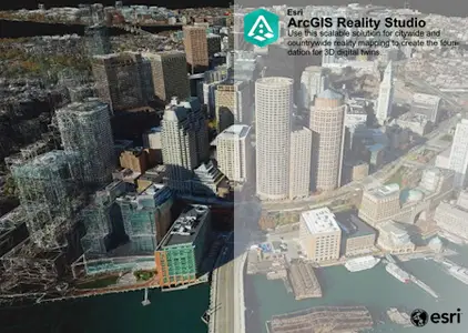
核心功能与特点
- 全新的 ArcGIS Reality 引擎:内置新一代核心渲染引擎,针对精度、处理速度和简易性进行了深度优化。
- 大规模实景制图:专为处理城市和国家级规模的航空摄影数据而设计,能够无缝整合来自各类多传感器的航测影像。
- 高保真数字孪生:能够生成满足测量级别的实景展示(如高精度 3D 网格、点云和正射影像),以高度逼真的物理世界视觉呈现来构建数字孪生体。
- 直观的工作流:通过引导式的捕获会话简化生产流程,用户可轻松完成图像对齐、添加地面控制点、生成产品和质量评估。
Esri, the global leader in spatial analytics technology, has released ArcGIS Reality Studio 2026.1.0 is a photogrammetry product that is optimized for precision, speed, and simplicity.
Reality Studio 2026.1 introduces new cloud processing capabilities, improves the quality and speed of results, enhances support for editing workflows, and delivers a more productive experience with an upgraded and more stable user interface.
ArcGIS Reality Studio is an advanced photogrammetry product optimized for precision, speed, and simplicity. This scalable solution for city and countrywide reality mapping is an important component of 3D digital twins. Align large collections of images captured by drones and aerial sensors across multiple flights to create highly accurate true orthos, 3D meshes, point clouds, and Gaussian splats. An intuitive map-centric user interface provides seamless workflows for the efficient creation, editing, and quality control of survey-grade products. Easily collaborate and share data within geographic information system (GIS) technology and mapping systems for photorealistic visualization and analysis.
In this video Esri experts reveal how they used ArcGIS Reality Studio to create incredibly accurate 3D representations of Harvard University and the entire city of Cambridge MA. See how 19 terabytes of high-resolution imagery was processed in ArcGIS Reality Studio in mere days (compared to traditional methods that often require MONTHS).
Esri , the global market leader in geographic information system (GIS) software, location intelligence, and mapping, helps customers unlock the full potential of data to improve operational and business results. Founded in 1969 in Redlands, California, USA, Esri software is deployed in hundreds of thousands of organizations globally, including Fortune 500 companies, government agencies, nonprofit institutions, and universities. Esri has regional offices, international distributors, and partners providing local support in over 100 countries on six continents. With its pioneering commitment to geospatial technology and analytics, Esri engineers the most innovative solutions that leverage a geographic approach to solving some of the world’s most complex problems by placing them in the crucial context of location.
官方网站:http://www.esri.com
此处内容需要权限查看
会员免费查看